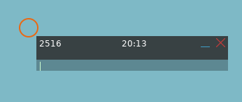
¶ Quick Reference:
- Access Map: Open the F10 map.
- Markpoint: Place a markpoint on the map.
- Name Entry: Enter tanker name (e.g.,
ARCO71). - Finalize: Click off the map to save.
¶ Optional Specifications
- Hold Radial:
ARCO71 69(69° outbound leg) - Hold Radial & Leg Length:
ARCO71 69 69(69° outbound leg, 69 nautical miles) - Hold Radial, Leg Length & Altitude:
ARCO71 06 94 FL200(6° outbound leg, 94 nautical miles, 20,000 feet)
¶ Basic Usage
-
Open the map with the F10 key.
-
Select the new markpoint button from the top toolbar:

-
Click on the map where you want the tanker to move to.
-
You should now see a markpoint pop up on the screen and input field for the text of the markpoint. You may need to click on the input field at the bottom of the markpoint pop up (the transparent part), to make typing in that field active.

-
Type the name of the tanker you want to move to that location in ALL CAPS, including the digits, no spaces. For example
ARCO71orSHELL21. -
Click off of the markpoint, anywhere else on the map.
Two things should happen at this point:
- The markpoint should disappear.
- The outbound track line for tanker should be redrawn at the markpoint position.
If the markpoint does not disappear when you click off of it, it is highly likely you have either misspelled the tanker name or are trying to use a tanker that is not spawned in the mission.
The tanker should now be moving to the new position!
¶ Advanced Usage
When typing in the tanker name to the markpoint, specific parameters can be set for tanker navigation:
-
Hold Radial: Specify the outbound leg bearing. Syntax:
TANKERNAME BEARING. Example:ARCO71 90for a 90-degree outbound leg. -
Hold Radial and Leg Distance: Define the outbound leg bearing and leg distance. Syntax:
TANKERNAME BEARING DISTANCE. Example:ARCO71 90 50for a 90-degree outbound leg with 50 nautical miles leg distance. -
Full Specification: Set outbound leg bearing, leg distance, and altitude. Syntax:
TANKERNAME BEARING DISTANCE ALTITUDE. Example:ARCO71 90 50 FL200orARCO71 90 50 20000for a 90-degree outbound leg with 50 nautical miles distance at 20,000 feet.-
Altitude Availability: Jackal determines if the specified altitude is available, as explained in the What Altitudes are Valid? and How Does Jackal Select Which Altitude to Place a Tanker? sections.
-
Formatting Altitude: Altitude can be expressed as
###for flight level (assumed),FL###, or#####for feet. -
Bearing Range: Must be between 1 and 360 degrees.
-
Distance Range: Must be between 10 and 100 nautical miles.
-
Spaces are required between each option to ensure correct parsing and processing of the commands.
If the markpoint does not disappear when you click off of it, it is highly likely you have either misspelled the tanker name or are trying to use a tanker that is not spawned in the mission. You may have also forgotten a space between parameters.
¶ What Altitudes are Valid?
Short Answer: Between 18000ft and 28000ft, at 1000ft intervals unless the mission maker has modified Jackal's preferences.
Valid tanker altitudes are defined by the mission's specified range between the tanker floor and tanker ceiling and must be divisible by the tanker deconfliction interval. The default settings are a floor of 18,000 feet, a ceiling of 28,000 feet, and a deconfliction interval of 1,000 feet. Consequently, valid altitudes are every 1,000 feet within this range, such as 19,000 feet, 20,000 feet, up to 28,000 feet, provided the weather is clear. The mission maker has the ability to alter the floor, ceiling, and deconfliction interval to create a wider or narrower altitude band for tankers.
When establishing active tanker slots, Jackal considers the mission's cloud layers. It will not create slots at altitudes that would fall within cloud layers, ensuring that tankers operate in VMC conditions.
¶ How Does Jackal Select Which Altitude to Place a Tanker?
Jackal has two directives when selecting an altitude for a tanker:
- Avoid altitude conflicts.
- Attempt to give the player what they asked for.
That logic ends up looking something like this:
- A player may request a specific altitude, but this is optional.
- If an altitude is requested, Jackal verifies its validity as a tanker altitude.
- If invalid, Jackal identifies the nearest valid altitude to use instead.
- Jackal then evaluates all available tanker slots for an altitude match.
- If the preferred slot is unclaimed, Jackal assigns it to the tanker.
- If the slot is claimed, Jackal assesses if the existing claim is beyond the desired leg length from the new request.
- If the existing claim is sufficiently distant, it is ignored as non-conflicting.
- Otherwise, the claim is considered conflicting.
- Jackal searches for the closest unclaimed slot to the initially requested altitude.
- Upon finding such a slot, Jackal assigns it.
- If no unclaimed slots are available, Jackal allocates the slot with the fewest claims.
- In case of a tie in claim counts, Jackal chooses the slot nearest to the initially requested altitude.