Joint Forces Commander - Joint Task Force 8
Operation Steel Claw
010800ZJUN01
TOP SECRET//SAND LAKE//ORCON
Distribution List:
- Joint Forces Air Component Commander, Joint Task Force Eight
- Joint Forces Naval Component Commander, Joint Task Force Eight
- Carrier Air Wing One
- Air Wing 13
- VMA-513
- 82d CAB
- 161st ARW
- 190th ARW
- 968th EAACS
- 55th Wing
- 7th Bomb Wing
- 509th Bomb Wing
- 711th SOS
- 2nd Bomb Wing
¶ Preface
The Airspace Special Instructions (SPINS) for Operation Steel Claw serve as a comprehensive directive to ensure consistent and coordinated air operations among all participating aircrew and flight leads. This document establishes standardized procedures that eliminate the need for repeated control measure adjustments with each Air Tasking Order (ATO), thereby enhancing operational efficiency, minimizing potential confusion, and reducing the risk of errors. The SPINS encompass critical aspects of airspace management, operational procedures, and communication protocols essential for mission success. All personnel involved in air operations within the Operation Steel Claw area of responsibility must adhere to these instructions. Flight leads are responsible for ensuring their crews comply with all relevant SPINS during mission planning and execution.
¶ (TS) Section 1 - General Theater Information
¶ Standard Units
¶ Time
Time will always be given in Zulu time (UTC), such as 12:00Z.
Please note that the local time zone for all countries involves is UTC +3.
¶ Positions
-
Pre-briefed positions will be given in Degrees Minutes Seconds (DMS) in the format:
N00° 00'00.000, E000° 00'00.000 -
Dynamic positions will be given in MGRS in the format:
00A AA 00000 00000. -
Airborne positions will be given in relation to a GEOREF in the format:
GEOREF BEARING DIST ALT
¶ Measurements
-
All distances will be in Nautical Miles (nmi)
-
All altitude and elevation will be in feet, and either be in MSL (implicit), or AGL (explicit).
¶ Standard Brevity
¶ (TS) Section 2 - Air Navigation Instructions
¶ Navigation Rules
¶ Flights Altitudes
Flights will adhere to prebriefed cruising altitudes given to them for deconfliction, if such altitudes are provided during a briefing.
Flights assigned to a control measure, such as a CAP Station or Kill Box, are implicitly granted the altitudes of that control measure.
Flights without a prebriefed cruising altitude, or unable to maintain their pre-briefed cruising altitude will adhere to 14 CFR § 91.159:
- Flights will operate at 18000ft or below
- Flights traveling East (Magnetic course 0-179 degrees) will travel at an odd thousand foot altitude + 500ft (17,500ft, 15,500ft).
- Flights traveling West (Magnetic course 180-359 degrees) will travel at an even thousand foot altitude + 500ft (16,500ft, 14,500ft).
Flights orbiting, holding, or maneuvering at a location, they will do so whole thousand foot altitudes (17,000ft, 18,000ft).
¶ Daytime Pre-assigned Altitudes
During the day, flights will be granted an exclusive 2000ft block between FL180 and FL320. Within that altitude block, flights are free to vertically deconflict with their own flight members as they see fit.
Valid daytime blocks are:
| FL180-FL199 |
| FL200-FL219 |
| FL220-FL239 |
| FL240-FL259 |
| FL260-FL279 |
| FL280-FL299 |
| FL300-FL320 |
¶ Nighttime Pre-assigned Altitudes
During the night, flights will be granted non-exclusive 4000ft blocks between FL180 and FL340. Within that altitude block, flights are free to vertifcally deconflict their own flight members as they see fit. Flight plans and launch times should be designed to minimize conflict with flights in the same altitude block.
Valid nighttime blocks are:
| FL180-FL219 |
| FL220-FL259 |
| FL260-FL299 |
| FL300-FL340 |
¶ Right of Way
Where applicable utilize 14 CFR § 91.113. Specifically:
Emergency Aircraft
Aircraft that have declared an emergency have right of way over all other aircraft.
Refueling Aircraft
Refueler aircraft (tankers) and aircraft rejoined with the tanker have right of way over all other flights, except for emergency aircraft.
Converging Aircraft
When aircraft or flights category are converging at approximately the same altitude (except head-on), the aircraft to the other’s right has the right-of-way. This means that between the two aircraft or flights, the entity on the left must yield.
Head-on Aircraft
When aircraft or flights are approaching each other head-on, each entity will alter their course to pass each other on the right.
Overtaking Aircraft
When an aircraft or flight is overtaking another, the overtaking entity will alter course to pass on the right.
¶ Airspace
¶ LLR-TASKFORCE “Union Station”
LLR-TASKFORCE is a 300nmi x 50nmi temporary restricted airspace in the Mediterranian Sea, 100nmi north of the Kemet coast. Coalition aircraft are permitted to operate inside it with authorization or for reasonable purposes to complete their current mission.
¶ P-404
Prohibited Airspace 404, encompasses most of Northwestern Kemet and all of its air force bases, from the ground to unlimited. Non-authorized aircraft are not allowed to operate in this airspace under any circumstances. P-404 constitutes a No Fly Zone where coalition aircraft are intended to use lethal force to enforce the NFZ provisions.
¶ R-403
Restricted Airspace 403, encompasses the Sinai Peninsula, from the ground to unlimited. It is sovereign Tyrian airspace, occupied by the Kemet armed forces at this current time. Civilian flight will not be approved into this airspace until safe passage can be guaranteed.
¶ LL-P15
LL-P15 is a prohibited airspace in Tyriana, 25nmi Southeast of Hatzerim AB. It contains nuclear research and storage facilities of Tyriana and is prohibited to all aircraft, including coalition aircraft.
¶ LL-P16
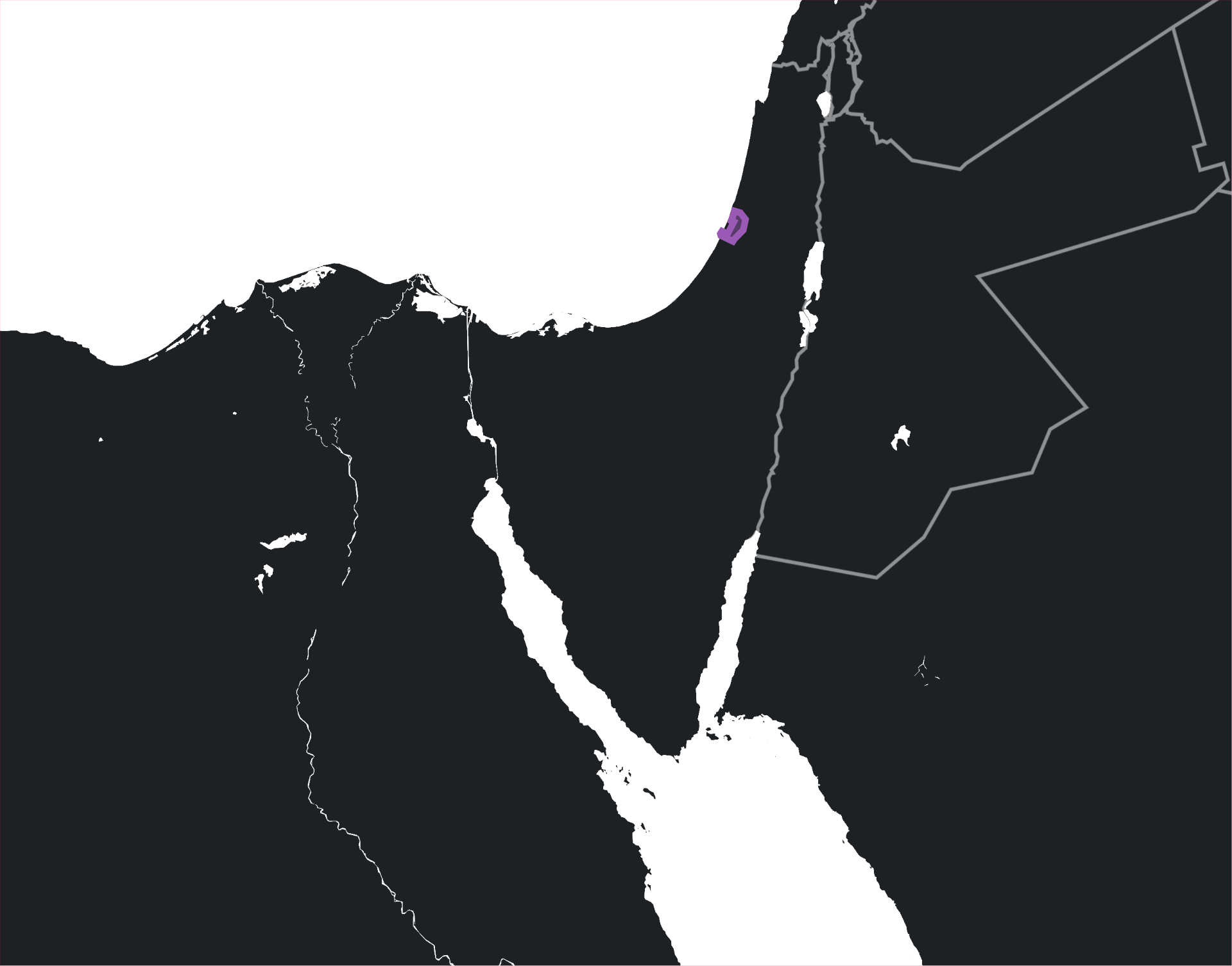
LL-P16 is a prohibited airspace in Tyriana, in immediate vicinity of Palmahim AB. It contains nuclear storage facilities of Tyriana and is prohibited to all aircraft, including coalition aircraft. Note that this airspace has a substantial imapct on coalition forces operating in or near Palmahim. Departures to the North, South, or East are not possible as they will violate LL-P16.
¶ LLBG
The LLBG airspace is the terminal airspace for Tel Aviv International and goes from the ground up to 10000ft for coalition aircraft. Coalition aircraft may enter the airspace with approval from Tel Aviv Center, but must adhere to the 250kt limitation within the airspace.

¶ Carrier Procedures
All aircraft operating within 50nmi of CVN-75 or another aircraft carrier will adhere to CV-NATOPS.
¶ Airfield Procedures
¶ Tel Nof Airbase (LLEK)
RWY36, 33L, 33R is non-standard RIGHT-HAND pattern due to deconfliction concerns with LL-P16.
All overhead breaks at LLEK must be to the East, due to deconfliction concerns with LL-P16
¶ Palmahim Air Base (LLPL)
Palmahim is surrounded on 3 sides by Airspace LL-P16. Coalition aircraft are not permitted in LL-P16 for any reason and are subject to lethal force if violating the airspace.
¶ Hatzerim Air Base
¶ Bun Gurion International (LLBG)
When manned, do not enter LLBG airspace without clearance from ATC.
¶ (TS) Section 3 - Command, Control and Communication Instructions
¶ Command and Control Agencies (C2)
All airborne units operating in the theater will be under the control of the airborne battlefield command and control center (ABCCC) under the callsign GAMEMASTER. An ABCCC will be airborne 24/7 under the responsibility of the 968th EACW operating out of Al Dhafra, AB in the Palm Emirates.
Tasking and target selection will be decided by the Operation Steel Claw JFACC, referred to as ARCHANGEL.
¶ C2 Agencies
| Callsign | Position |
|---|---|
GAMEMASTER |
Airborne Battlefield Command and Control Center (ABCCC) Actual |
ARCHANGEL |
Joint Forces Air Component Commander (JFACC) |
CLOSEOUT |
Air Intercept Controller (AIC) in P-404 |
DARKSTAR |
Air Intercept Controller (AIC) in R-403 |
HIGHLANDER |
Joint Forces Land Component Commander (JFLCC) |
LONE WARRIOR |
CVN-75 USS. Harry S. Truman |
RED CROWN |
Air Defense Coordinator in Union Station |
¶ Air Intercept Controllers (AIC)
-
Fighters in P-404, and Union Station will be controlled by
CLOSEOUTon TAC GOLD 5 (242.50 Mhz), with TAC VIOLET 6 (242.75 Mhz) reserved for a 2nd AIC. -
Fighters in R-403 and over Tyriana will be controlled by
DARKSTARon TAC MINT 7 (231.00 Mhz), with TAC PEACH 8 (231.25 Mhz) reserved for a 2nd AIC. -
In the event that positions are collapsed to a single position, responsbility will fall to
CLOSEOUTon TAC GOLD 5.
Unless AIC positions have been collapsed, either as briefed, or during the mission, when fighters intend to cross between P-404/R-403 airspaces, when 10nmi from the boundary fighters should announce on their current channel their intent to chance airspace, and then automatically switch to the new airspace’s main frequency uncommanded. Fighters currently executing an intercept on a contact should remain with their current AIC for the duration of the intercept until the fighters announce reset, abort, or otherwise indicate to their current AIC that they are discontinuing target engagement,
¶ Geographical References (GEOREFs) and Bullseye
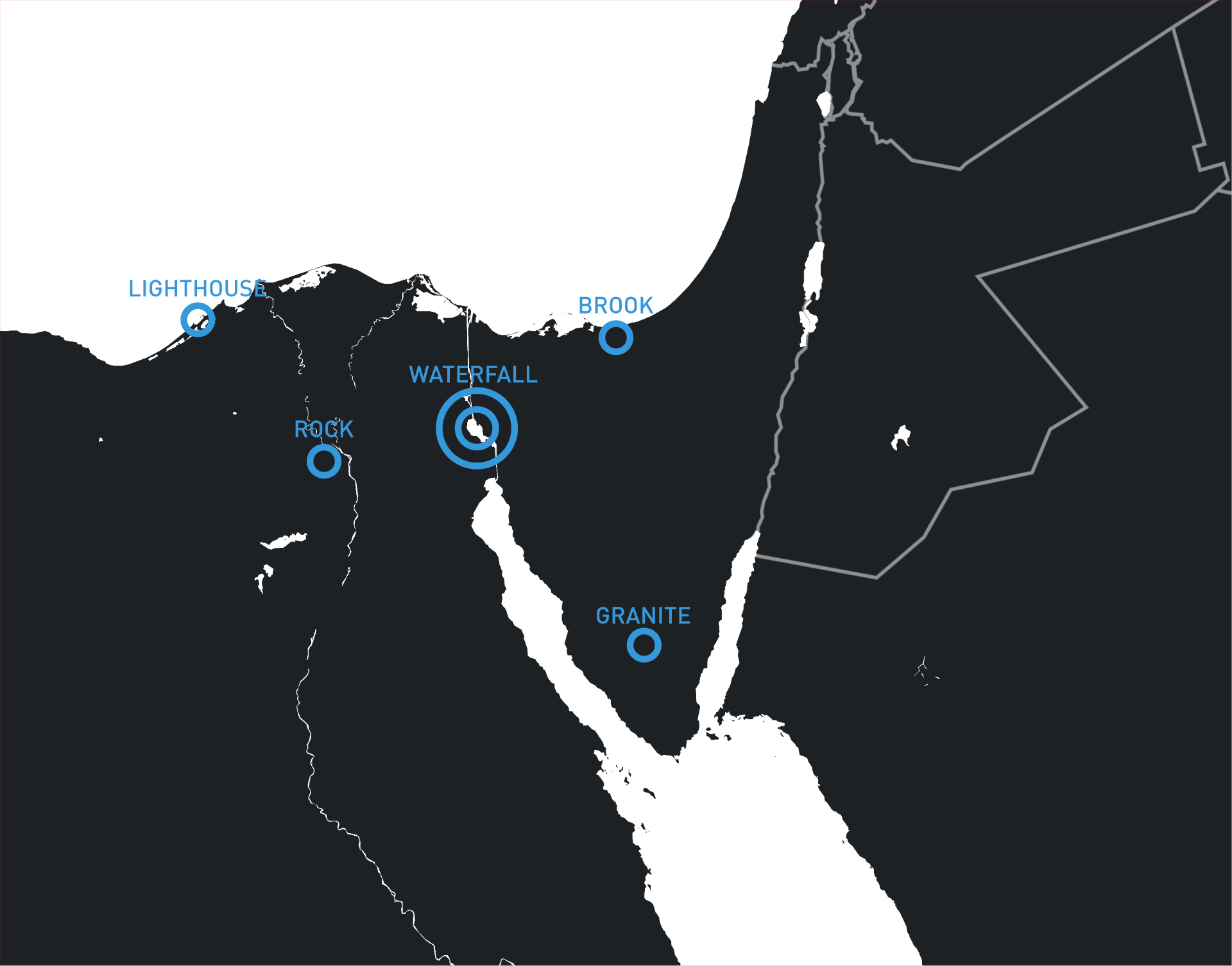
¶ Primary Bullseye
Primary Bullseye for this theater will be Great Bitter Lake, IVO Al Ismailiya, Kemet designated as WATERFALL. WATERFALL conveniently splits down the middle between airspaces P-404 and R-403.
¶ Additional GEOREFs
| Designation | Description | Lat | Lon | Note |
|---|---|---|---|---|
ROCK |
Great Pyramid | N 29°58’45" | E 31°08’03" | Recommended Bullseye when operating in P-404 |
LIGHTHOUSE |
Port of Alexandria | N 31°11’41" | E 29°52’21" | |
BROOK |
El Arish Airport | N 31°03’20" | E 33°49’40" | Recommended Bullseye when operating in R-403 |
GRANITE |
Mount Sinai | N 28°30’37" | E 33°57’17" | Recommended Bullseye for Red Sea and souther ops |
¶ Theater Rules of Engagement (ROE)
¶ Air to Air ROE
The Rules of Engagement (ROE) for air-to-air (A-A) combat delineate the conditions under which an aircraft is authorized to engage with lethal fire. Engagements are permissible under two primary conditions: direct attack or clearance from C2.
¶ Engagement Authorization
-
Direct Attack: Engagement is authorized if the friendly aircraft is actively attacked by a contact that meets Hostile Intent Criteria as defined below.
-
C2 Clearance: Engagement is authorized upon receiving explicit clearance from GAMEMASTER, CLOSEOUT, or DARKSTAR against a specific contact, group, or picture.
¶ Hostile Intent Criteria
Hostile Intent Criteria (HIC) is required to classify any contact as HOSTILE in the theater and to engage that contact with lethal force. HIC can be met by fulfilling 1 or more of the following qualifications: 1) Direction Engagement, 2) Indirect Support, 3) Threatening Manuevers, 4) Aggressive Posture, or 5) No Fly Zone Violation. A contact cannot meet the definition of Hostile without either satisfying 1 or more HIC, or without being classified as HOSTILE by a C2 Agency.
- Direct Engagement:
All of
- The contact engages BLUFOR with a weapons system, resulting in weapons release against friendly fighters.
OR
- Indirect Support:
All of
- The contact has been classified as a BANDIT by C2
- The contact meets the requirements to be classified as HOSTILE
- The bandit contributes to a weapon system by providing sensor data, leading to weapons release against BLUFOR.
OR
- Threatening Maneuvers:
All of
- The contact has been classified as a BANDIT by C2
- The bandit persistently maneuvers to maintain a radar SPIKE on a BLUFOR aircraft or firing solution while within the bandit’s missile employment zone
OR
- Aggressive Posture:
All of
- The contact has been classified as a BANDIT by C2
- The bandit does not verbally or non-verbally respond to hails on emergency frequency to change their direction of travel.
- The bandit persistently maneuvers in an aggressive manner to approach BLUFOR
- The bandit conducts flight in a manner inconsistent with internationally upheld standards for safe and legal flight.
OR
- No Fly Zone Violation:
All of
- The contact does not meet the classification of FRIENDLY or NEUTRAL
- The contact is within airspace P-404 or Union Station
¶ 2.3.4 Self Defense
Section 2.4 Theater Rules of Engagement, and the document in its entirety, does not restrict the inherent right to individual self-defense.
¶ 2.4 Identification Criteria
Any CONTACT may be classified by the following criteria by either C2, or by the agreement of two or more flight leads if C2 is unable to provide a classification.
¶ FRIENDLY Identification
- Any of the following:
- Valid Mode 4 interrogation response.
- Surveillance or fighter track classified as friendly.
- PPLI track indicating friendly status.
¶ NEUTRAL Identification
- Any of the following:
- Visual or electro-optical identification as a civilian or non-combatant state aircraft.
- NCTR identification of a civilian aircraft model.
- Valid Mode 3/C response and navigation on published air routes.
¶ BANDIT Identification
- Visual or electro-optical identification as an aircraft used by hostile forces.
OR - At least FOUR (4) of the following Presence of Enemy Indicators (PEIs):
- No or invalid Mode 4 response.
- PPLI track showing enemy unit.
- Origin from enemy airfield or territory (OUTLAW status).
- RWR match to hostile aircraft model not used by friendly forces.
- Supersonic flight.
- Engagement in maneuvers typical of enemy combat air patrol or intercept.
¶ HOSTILE Identification
- Fulfillment of any Hostile Intent Criteria.
¶ Communication Plan
¶ TACAN
¶ Naval Units
CVN-75 USS. Harry S. Truman
75X TACAN Identifier: KU
LHA-1 USS. Tarawa
1X TACAN Identifier: MZ
CG-63 USS. Cowpens
2X TACAN Identifier: RW
CG-50 USS> Valley Forge
3X TACAN Identifier: VF
¶ Laser Codes
Please reference the Laser Deconfliction Plan.
¶ Link 16
The following Link 16 STN IDs will be assigned to flights:
| Flight | STN ID Range |
|---|---|
| Sol | 0210* |
| Inferno | 0220* |
| Sundial | 0230* |
| Liner | 0240* |
| Spartan | 0310* |
| Ares | 0320* |
| Apollo | 0330* |
| Artemis | 0340* |
| Plasma | 0110* |
| Fury | 0120* |
| Disco | 0130* |
| Rage | 0140* |
| E-2 Missions | 0777* |
| E-3 Missions | 0776* |
¶ Mission Procedures
¶ Briefing Product Distribution
There will be three broadly available briefing products available for flight leads preceding a mission:
-
The Frag Order, via fragorders.com. Flight leads will be expected to review the overall situation and their flight information through frag orders. The Frag Order is a fluid briefing product and may be continuously updated until mission start
-
The Intel Drop. This will be provided after the CAOC meeting for the upcoming mission and will include a minimum amount of details to guide training and preparation and show preliminary task selection.
-
The Briefing Slides. This is the main briefing document, which will become available on the day of the operation.
¶ Frag Orders
Flight level planning will be conducted with Frag Orders via this link: https://fragorders.com/public_frag_order/9KnkTBm3Wk2uR6D2qtrC.
A link to the Frag Order will be provided in the current missions’s #operations-room thread. and in the #air-tasking-order on the day of operations.
¶ Intel Drops
Intel drops provide the minimum amount of information for squadrons to build flight comps, have a broad overview of taskins for the next mission, and determine worst case threats they should prepare for. The Intel Drop is product that is intended to be generated quickly after the conclusion of a CAOC meeting.
The Intel Drop will be the first message posted in a new #operations-room thread for the next mission.
¶ Briefing Slides
The briefing slides are a Google Slides deck that will be completed by the JFC and JFACC, to be available NLT 3 hours before the op. It will contain all details unique to that mission, including a threat overview, battlespace review, control measures, coordination measures, and target overview. A low portion of the Briefing Slides will be dedicated to flight specific waypoints, loadouts, and targets and as such Flight Leads should focus on the Frag Orders leading up to the operation.
¶ Mass Briefing
Mass Briefings will take place at the normal CSG8 operation start time. The schedule of the briefing will be:
- JFC or JFACC briefing ( 15 minutes )
- AIC briefing ( 2 minutes )
- Questions ( 3-8 minutes )
Please try and answer your own questions by reviewing this SPINS and Frag Orders
¶ Flight Briefing
Flights will be given 15 minutes to brief before server restart.
¶ Controller Check-In
As soon as a flight is no longer in an ATC or CATCC controlled environment, the flight will check in with their designated AIC on a TAC channel via the following method:
-
Tune to the TAC channel
-
Wait 10 seconds
-
If channel is clear, ALL flight members should report their callsigns in order on that channel
“RAGE11” “RAGE12” “RAGE13” “RAGE14”
“ANYFACE, RAGE11. Checking in [As Fragged | With Exceptions ].” -
AIC will then respond with an Alpha Check to the primary GEOREF for the mission.
-
If good Alpha Check, report exceptions, if any exist.
-
Update AIC on your current action: [ Proceeding to… | Going to CAP Station … | Going to Tanker SHELL## … ]
¶ Strike Coordination Roll Call
If a package has pre-briefed, time sensitive sequence of events, the AIC on frequency will perform a ROLL CALL at T-5 minutes to ACTION. AIC will call on each flight lead, who should respond if they are READY or not, and if they will make their time on target obligations for the upcoming attack sequence.
If all flights complete the roll call as READY, the plan will proceed as fragged.
At T-00:03, AIC will call “STRIKE, ACTION”.
¶ Rolex
If 1 or more flights is not ready, AIC will work with the package commander to ROLEX the attack sequence.
AIC will gather the needs of all flights, while the package commander considers the rammifications of ROLEXes of different durations.
The AIC and Package Commander will then brief the net with a new start datum, and AIC will check with each flight that they can accept the ROLEX time.
A Roll Call will be reinitiated at the T-5 minutes to ACTION.
¶ In-flight Reports
¶ Mandatory Reports
¶ BDA Report
¶ Spot Report
¶ SAM Report
¶ Controller Check-Out
¶ After Action Report (AAR) (Discord)
Please use the following template for your report:
## FLIGHTNAME

### SUSTAINS
- What did your flight do well? What things would you like to call out as positively impacting the mission?

### IMPROVES
- What did your flight do not-so-well that you think should be training topic, or could require SOP adjustments? Where can a focus on improvement be made?

### DEVIATIONS
- How did you deviate from the plan as briefed and why did this occur? Specifically focused on how the briefing and mission plan failed to accomodate the success of the mission.

### BDA
- What were your targetting effects for the day?
¶ (TS) Section 4 - Air to Air Instructions
¶ Air to Air Control Measures
¶ CAP Stations
In the event of a heightened threat level, ARCHANGEL designates specific Combat Air Patrol (CAP) stations for operational use. Station activation is determined based on real-time intelligence analysis of the opposing force threat, with stations activated according to the vector from which the threat is likely to approach.
Each CAP station maintains a standard left-hand orbit pattern with maximum 30 nautical mile legs ( Roughly 4 minute legs at M0.7 ). The station is intended by the JFC to be executed by two flights of two aircraft each, operating on opposing legs of the station to ensure continuous area coverage and threat engagement capability. Flight leads may deviate from their station as necessary to best complete their objectives. However, the CAOC will make no attempt to deconflict other flights away from the CAP flights via their flight plans in such cases.
CAP Stations
| Station ID | Location | Sector | Latitude | Longitude | Inbound Course | Altitude Block |
|---|---|---|---|---|---|---|
| CAP DENVER | West Picket | P-404B | N 32°00’51" | E 30°18’26" | 180° | FL220 - FL400 |
| CAP PHOENIX | IVO Rosetta | P-404B | N 31°15’21" | E 30°44’46" | 135° | FL250 - FL400 |
| CAP CHICAGO | Central Picket | P-404A | N 32°02’37" | E 31°48’20" | 180° | FL220 - FL400 |
| CAP ORLEANS | IVO Damietta | P-404A | N 31°15’51" | E 31°49’32" | 180° | FL250 - FL400 |
| CAP NEWYORK | East Picket | R-403A | N 32°04’30" | E 33°19’13" | 180° | FL220 - FL400 |
| CAP NASHVILLE | North of Baluza and El Arish | R-403A | N 31°30’46" | E 32°55’57" | 225° | FL220 - FL400 |
| CAP ATLANTA | Hatzerim AB | LLLL FIR | N 31°17’32" | E 34°44’53" | 225° | FL220 - FL400 |
| CAP MIAMI | Between El Gora and Ramon | R-403B | N 30°45’18" | E 34°06’38" | 225° | FL250 - FL400 |
Note that the mimumum altitude for CAP stations varies depending on the estimated threat from ground based fire.
Color Code
Inactive Stations will be marked Grey (128,128,128)
Active Stations will be marked Purple (128,0,255)
For the day’s ATO, if a flight is assigned to CAP, they will be fragged to a Station ID for a set duration. While the CAP altitude is generally determined by the flight lead, any adjustments outside the pre-designated altitude block must be coordinated with GAMEMASTER or ARCHANGEL and the relevant air traffic control authorities, except when altitude changes are required for self-defense purposes.
¶ Figher Sweep (FTR SWEEP)
¶ Acceptable Level of Risk ( Counterair Operations )
ARCHANGEL will manage the acceptance of risk in air-to-air engagements using the Acceptable Level of Risk (ALR) table. ARCHANGEL sets a standing ALR for each Air Tasking Order (ATO) period, which flight leads are expected to follow unless the ALR is adjusted by GAMEMASTER or ARCHANGEL during the ATO period. The ALR serves as a starting point and boundary for flight leads to determine appropriate air-to-air tactics based on the engagement scenario.
If flight leads, during the mission planning stage, assess that the current ATO’s objectives cannot be met without exceeding the set ALR, they must promptly inform ARCHANGEL to address the planning discrepancy.
During the execution of a mission, if a flight lead concludes that maintaining the ATO’s ALR is no longer feasible, they are required to immediately report to GAMEMASTER. This allows for real-time adjustments to the operational plan, ensuring it aligns with the evolving dynamics of the engagement.
¶ (TS) Section 5 - Air to Ground Instructions
¶ Air to Ground Control Measures
¶ Minimum Risk Routes (MRRs)
Minimum Risk Routes (MRRs) are air corridors through Kemet, 20nmi wide, and intended to be safe passage routes through Kemet. SEAD flights will be tasked with sweeping each Minimum Risk Routes, every 6-12 hours to ensure that no enemy SAM MEZ will tresspass the covered area of the MRR. All strike packages using a MRR must still be accompanied by a FTR SWEEP flight or swing role FTR SWEEP/SEAD flight when transitting a corridor so long as the KRAF is capable of mounting a substantial counter air operation. GAMEMASTER and ARCHANGEL will be responsible for ensuring the integrity of MRRs.
MRRs do not need to be opened or closed, and all coalition aircraft can transit an MRR at will. They are only meant as a planning and strike coordination tool for the CAOC and to provide an assertion of safety from ground based air defense when the MRR integrity is intact. FTR SWEEP flights are also intended to use MRRs as patrol areas and to help their flight leads reference where friendly strike fighters are likely to be, to reduce the burden of memorizing a new flight plan every single sortie.
It is the intent of the JFC that MRRs and their consistent use will allow flight leads to build a solid geographical study of the operations area, and to allow them to develop better, faster situational awareness in combat.
¶ Route 1
Route 1 cuts down from the northern tip of Kemet’s Mediterranean coast all the way down to the south of Cairo, IVO Helwan. The JFC would like for this route to be used by the Navy coming from Union Station hitting targets in Cairo. The primary challenge for Route 1 for the CAOC is the high concentration of enemy air defenses, both ground and airborne, along Route 1. The JFC does not expect this route to be open within the first 3 days of combat.
¶ Route 66
Route 66 cuts Ramon Airbase to Suez and encompasses occupied Sinai, and the Suez canal’s southern entrance. The JFC would like for this route to be used by the Air Force coming from Tel Nof, for hitting targets in both Suez and Cairo. The primary challenge along Route 66 will be the highly mobile, army attached ground based air defense, however a consistent SEAD presence should allow for this route to be opened quickly. It is likely to be the safest and most predictable strike route into Cairo in the early phases of Operation Steel Claw.
¶ Route 5
Route 5 cuts from West of Alexandria to West of Sixth of October. The JFC would like for this route to be used in the early phases of Operation Steel Claw by the Navy, in the event the JFACC determines that targets in Cairo need be targeted in the early phase of the Operation, as it side steps most ground based defenses.
¶ Blue Kill Box (BKB)
Blue Kill Boxes will be defined in accordance with TTP-220-FSCM FIRE SUPPORT COORDINATION MEASURES
BKBs, by default will go from SFC to 18000ft and encompass an area no smaller than 20nmi x 20nmi.
When multiple flights are operating in a BKB, a Kill Box Controller (KBC) in the form of a FAC(A) or SCAR flight will be present in the Kill Box.
BKBs will be identified by an ID starting at BKB001 on the map.
¶ Purple Kill Box (PKB)
Purple Kill Boxes will be defined in accordance with TTP-220-FSCM FIRE SUPPORT COORDINATION MEASURES
PKBs, by default will go from 10000ft to 18000ft and encompass an area no smaller than 20nmi x 20nmi.
When multiple flights are operating in a PKB, a Kill Box Controller (KBC) in the form of a FAC(A) or SCAR flight will be present in the Kill Box.
PKBs will be identified by an ID starting at PKB001 on the map.
¶ No Fire Area (NFA)
No Fire Areas Kill Boxes will be defined in accordance with TTP-220-FSCM FIRE SUPPORT COORDINATION MEASURES
NFAs by default go from SFC to UNLMTD.
NFAs will be identified by an ID starting at NFA001 on the map.